
Hello and welcome to another Notebook from the North! This is not just any old plog episode however, it’s the 50th one! Who’d have thought we’d get this far eh? To celebrate this milestone, we have a special expert guest writer- the wonderful Greta Ferloni. Greta’s research work has taken her from Jerusalem to Italy to the Netherlands, with her skills lying in detailed mapping of everything from physical structures to sounds. She has now turned her attention north, currently doing a PhD in Geography at the University of Durham studying sea-ice mobility in the Bering Sea.
This week she has written for us an article all about sea ice in the Arctic, and how whilst in most places this ice is rapidly meting away, the Bering Sea, sitting between Russia and Alaska, seems to be ignoring convention and doing its own thing. It makes for a really interesting read and shows just how important it is to be aware of variation in the Arctic and in climate. Hope you enjoy it as much as I did! Greta- over to you:

Sea ice in the Arctic is decreasing rather quickly, signalling to us the drastic impacts that climate change is having on our planet. Yet oddly, the whole Arctic isn’t melting at the same rate. Why is this? And what does this mean for the animals, plants and people who rely on sea ice for survival?
What’s going on with sea ice in the Arctic?
The Arctic is big! Yes yes, there’s many ways of defining ‘the Arctic’ – if you want to know more, you can have a read of Notebook from the North’s blogpost #4. Either way, the average area in the Northern Hemisphere covered by sea ice every year is around 11 million km2, which is just larger than all of Europe! Depending on where in the Arctic you are then, each area is susceptible to different weather patterns, winds, ocean currents, temperatures, ocean depths and coastlines that all play a role in defining how and when sea ice will occur.
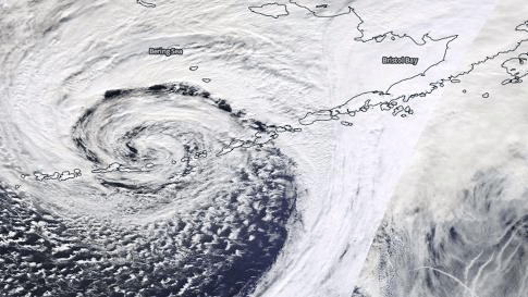
And this is where the Bering Sea is an interesting example. It is the only region in the Arctic that, until recently, was showing (slightly) increasing trends in sea ice cover! This is a colossal achievement given that the rest of the Arctic has steadily lost over 2 million km2 in sea ice over the past 40 years and shows no sign of stopping. In fact, the Bering Sea (and more generally the North-western part of North America) is also the only region in the Northern Hemisphere that is cooling down instead of warming up – and this is not just sea ice, it’s surface temperatures overall! While the recent winters of 2017-2019 did bring massive declines in sea ice in the Bering Sea, the overall ice trends there remain a curious example of a region in the Arctic that was not systematically and drastically losing sea ice, as can be seen in the graphs below.

So why did the Bering Sea have more sea ice?
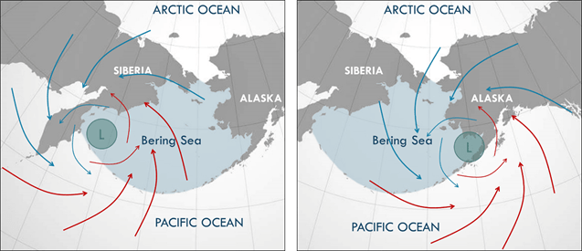
The Bering Sea is wedged between Alaska (United States) and Siberia (Russia). At its northern point is the Bering Strait, which connects the Bering Sea to the Chuckchi Sea and further out the Arctic Ocean, and to the south it opens onto the Pacific Ocean, divided only by a straggly chain of islands, the Aleutian Islands. An interesting feature of the Bering Sea is the shape of its basin underneath the water. It has a broad and shallow eastern shelf extending off the coast of Alaska, reaching a maximum depth of about 200 m (which, given that our oceans average out at around 3,700 m deep, is not very deep at all!). After about 500 km of this shelf, the basin suddenly plummets down to 3,000 m.

Because part of the Sea is so shallow, it can’t store a lot of heat from the previous summer, and any warm waters coming in from the Pacific Ocean are blocked out of this shallow shelf by this sudden ‘step’ in seabed. This means that this nice shallow area of water can cool down quickly in winter, creating the perfect conditions for sea ice to form.
On top of having the perfect breeding grounds for sea ice, the Bering Sea finds itself in a strategic location from an atmospheric point of view – it sits right underneath a low-pressure system called the Aleutian Low. You have to imagine the Aleutian Low like water going down a sink – a whirlwind spinning anti-clockwise, grabbing whatever it can find and dragging it down with it. So, what the Aleutian Low is able to do is drag warm air from the Pacific and pump it into the Bering Sea, while simultaneously dragging cold air in from the Arctic. Whether it is mostly hot (southerly) or cold (northerly) air being pumped into the Bering Sea depends on the location of the Aleutian Low for that specific winter. If the Aleutian Low moves west towards Siberia, winds in the Bering Sea are mostly from the south, bringing in warm air from the Pacific and decreasing the amount of sea ice that can form that year. If, however, the Aleutian Low moves to the east above Alaska, the airflow is from the north, bringing in nice and cold winds that give us the perfect conditions for sea ice to form! Studies have shown that in recent years, the Aleutian Low has been moving east in the winter, bringing more cold air in from the north and helping to contrast the effects of climate change as the planet is warming up as a whole.
The northerly winds are not just important for the cold air they bring in. They also move sea ice southwards in the Bering Sea in a ‘conveyor belt’ system that helps the ice to advance. As the northern part of the Bering Sea is generally colder, sea ice forms here more easily than in the south. Winds blowing southward, therefore, move the sea ice down, where waters are warmer and sea ice struggles to form. When sea ice meets warmer southern waters it melts, and while this temporarily decreases sea-ice extent, it actually cools down the water column, allowing the next bit of ice to advance further and repeat the melting-cooling process. Voilà!
This does, however, have a tipping point. The sea ice eventually reaches waters where the cold from the melting ice is outweighed by the depth and heat of the southern water. It is here that the sea ice in the Bering Sea stops, unable to advance any further.
As the winds that drive these processes are a result of the Aleutian Low, and the Aleutian Low acts most strongly on the Bering Sea, the rest of the Arctic cannot benefit from these favourable conditions. Simply put, this is why we haven’t been getting such a drastic decrease in sea ice in the Bering Sea compared to the rest of the Arctic.
What does this mean for animals, plants and people?
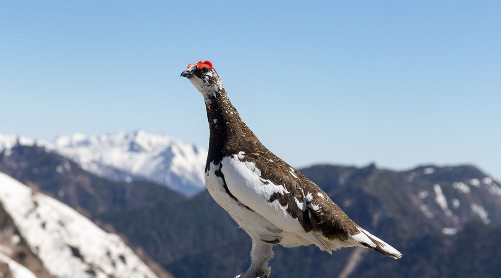
Sea ice is a very important part of Arctic marine ecosystems. Polar bears use it to get from one place to another and for hunting on, walruses rest on it when they’re pupping, and seals hide under it to escape their predators, such as polar bears. Sea ice is also important to people, especially Indigenous communities, who rely on it for travelling between places, hunting whales for food and as an integral part of their culture and history. This all relies on the ice being stable, thick and lasting for a long time in winter, as well as for the weather to be cold but not stormy. This weather also needs to be predictable, so that both humans and animals can tell in advance when it will allow ice to form and melt each year.
Studying and understanding this region better is important for a variety of reasons, part of which is- it’s really quite a complex area. The Bering Sea is one of the most biologically productive regions of the world, supporting one of the United States’ most valuable fisheries, as well as significant populations of marine mammals and birds. As these rely on habitats heavily influenced by sea ice, changing sea-ice conditions may have drastic impacts on the ecosystems, economies, livelihoods and cultural practices of this region. Overall, less sea ice means a northward shift of species – Arctic fish species will be forced to move northward as temperatures further south become too warm for them. They in turn will be replaced by subarctic species that be happy to move northward as temperatures become warmer. Larger predators will follow, such as whales, seals and polar bears. However, it can get more complicated as some underwater organisms like phytoplankton require light to grow and reproduce, which they can get more of if there is less sea ice blocking the light, i.e. if it is thinner, or if it starts to melt earlier. Phytoplankton is fundamental to the Arctic food web, feeding large organisms such as whales, so this could potentially attract more whales to regions losing most sea ice, instead of the other way around!
Another complicating issue is that precisely because Bering Sea weather is so localised due to the Aleutian Low, it can easily vary from one year to the next, depending on where the Aleutian Low moves to. The shallow waters on the shelf also mean that the Bering Sea holds little ‘memory’ of the previous year’s temperatures, allowing quick changes in sea ice conditions between years. This makes prediction pretty tricky business… we’ll just have to wait and see what happens next winter!
More information:
If you want to keep up to date with Greta and her work you can follow her Arctic adventures on Twitter @GretaFerloni
Bering Sea – https://www.britannica.com/place/Bering-Sea
Factors affecting Arctic climate – https://nsidc.org/cryosphere/arctic-meteorology/factors_affecting_climate_weather.html
Cover photo: ESA/NASA/Public Domain


Leave a comment